
History |
159 Derby Street History Project

The 159 Derby Street History Project is an ongoing collection of research and artifacts about our historic building and the property our galleries occupies. There's a long history of merchants, people, and stories connected to this important piece of land and the house itself.
Do you know about the amazing history of 159 Derby Street? This historic location has included ship builders, sail makers, distillers, even a paper stamper. Did you know the property dates to the 1650's? Or that is was once home to Benjamin Hawkes? Ever heard of Tuckers Wharf? How did Kosciuzco Street get its name? Did your grandparents attended the Ukrainian Working Man's Association?
We're seeking additional information. if you wish to help please send us any stories, photos, and maps you may find. Do you have family photos from the Derby Neighborhood? Maybe your grandfather attended the Ukrainian’s Workingmen’s Association? Please contact us at info@salemarts.org with any information you can add to our history project.
We especially want to thank Dr. Mary Frances (Franny) Zawadzki, Art and Visual Culture Historian, for writing the content below, sourcing maps and illustrations, and her valuable insights on this project.

The Property
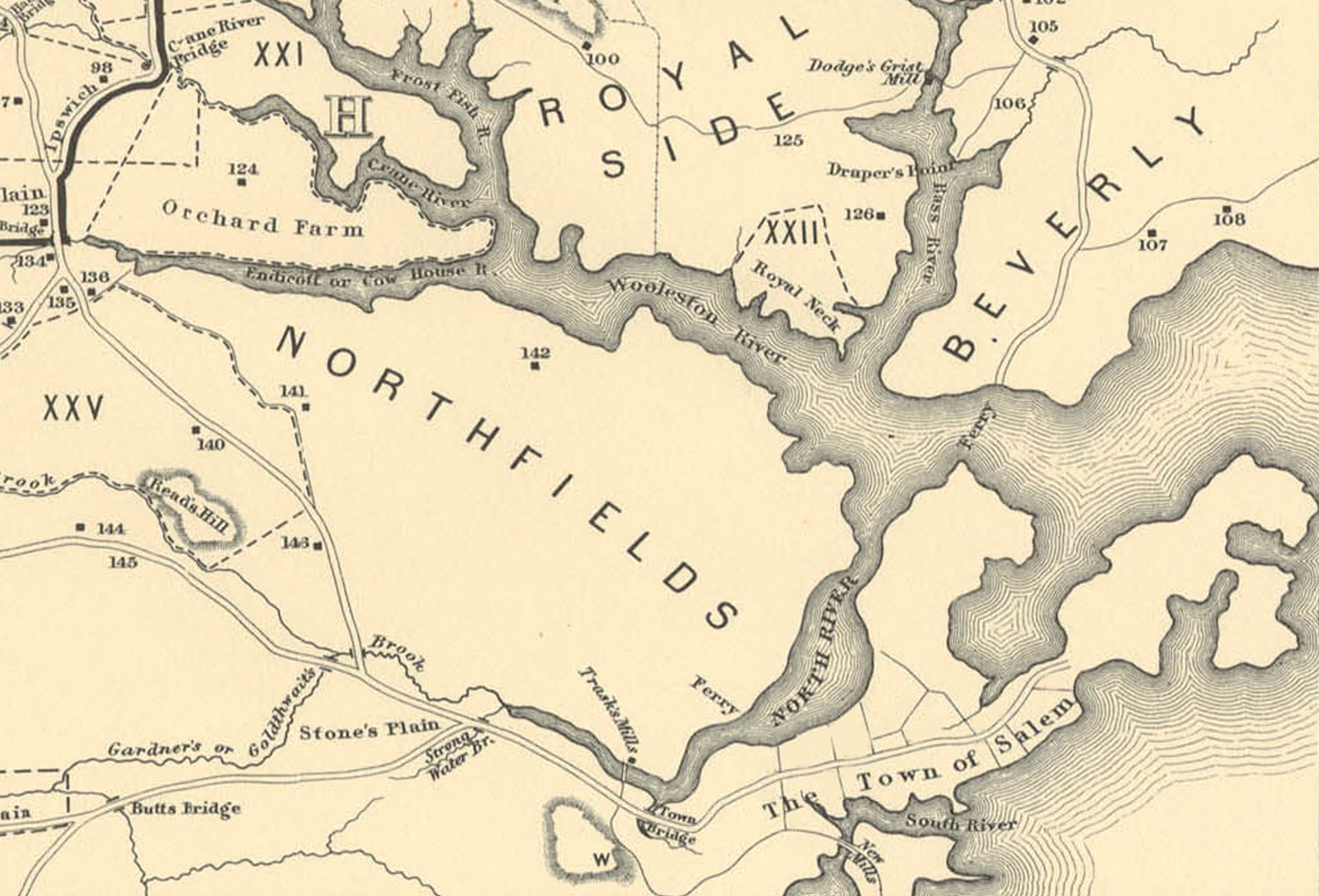
Map #1: Upham, William P. (William Phineas). “Map of Salem Village in 1692,.” Map. 1866. Salem Public Library. https://digitalheritage.noblenet.org/salem/items/show/107.
Prior to 1700
In 1626, Master Roger Conant, a salter by trade, and small group of settlers, the "Old Planters," founded Naumkeag, "the fishing place." By 1628, the Massachusetts Bay Company bought out the original investment company, the Dorchester Company, and a new governor was appointed, John Endecott, and Naumkeag was renamed Salem, "place of peace."
Between 1630 and 1700, Salem built a dominant commercial fishing fleet that provided enough fish for its residents and for its growing international trade activities. The coastline of Salem, including the land you are standing on, was primarily used for shipbuilding, fish flakes (fish-drying stations), and, most importantly, maritime trade. The lucrative West Indies trade helped establish a growing "merchant class" who were responsible for building some of Salem’s most historic buildings, such as the Capt. John Turner House (House of Seven Gables).
The businesses, structures, and property in this area (Ward 1 and 2) were predominately owned and operated by men and families who were associated with fishing, shipbuilding, or maritime trade. According to The Essex Antiquarian, volume 10 (1906), the ownership of the property in the 17th century was as follows:
1652 - John Swasey sold the lot and a dwelling to widow Dorothy King on January 15, 1652
1653 - Mrs. King sold the same estate to Thomas Johnson and Thomas Reignolds on October 21, 1653
1654 - Mr. Reignolds released his interest in the property to Mr. Johnson on February 20, 1654.
1654 - Mr. Johnson sold the house and lot to Adam Westgate, mariner, on June 29, 1654.
1685 - Mr. Westgate transferred the deed to his son, John Westgate on April 3, 1685.
1690 - John Westgate mortgaged the house and land to Lt. Thomas Gardner on November 17, 1690.
1698 - The land and dwelling came into possession of Adam Westgate again, who sold the property to Nicholas Chattwell, mariner, sometime before 1698.
1698 - Mr. Chattwell sold the land and a dwelling to Thomas Downing, a Salem merchant, on May 14, 1698.
1700 - 1850
|
|


Map #2: Freeman, William W. K. “Part of Salem in 1700, based on the Research of Sidney Perley." Map. 1933. Salem Public Library. https://digitalheritage.noblenet.org/salem/items/show/36. | Map #2a: Perley, Sidney. "Salem in 1700, no. 24." Illustration in The Essex Antiquarian: An Illustrated Magazine Devoted to the Biography, Genealogy, History and Antiquities of Essex County Massachusetts 10 (Jan 1906): 114. https://www.google.com/books/edition/_/l7CQM7FcNvwC?hl=en&gbpv=1&pg=PA125&dq=Salems+Thomas+Downing+House |
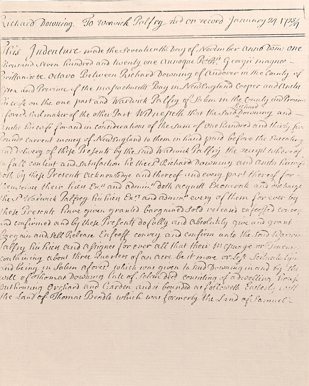
On May 14, 1698, Nicholas Chattwell sold the property to the merchant, Thomas Downing, who shared his property with his cousin, Richard Downing, a cooper. A contemporary description of the property states that a dwelling house and shop and frame were located on 5/8 acres of land. The land contained a garden and orchard. The house, itself, was comprised of a "kitchen, kitchen chamber, hall, hall chamber, leanto, etc." (Essex Antiquarian, 126). According to the research done by Joyce King, the Downing estate was a large stretch of land that included all of present day Kosciusko Street and Palfrey Court.
Thomas Downing’s wife died before him; therefore, he left the property and buildings to his cousin when he died in 1702.
Richard Downing sold the property to Warwick Palfrey, a sailmaker, on November 17, 1721. Upon his death in 1756, the house, buildings, gardens, and orchard was left to his oldest son, Warwick Palfrey. The Palfrey businesses included a distillery, which connects the family to the West Indies sugar trade and rum-making.
|
|
|


Map #3: Saunders, Jonathan Peele, and Annin & Smith. "Plan of the Town of Salem in the Commonwealth of Massachusetts." Map. 1820. Norman B. Leventhal Map & Education Center. https://collections.leventhalmap.org/search/commonwealth:3f4631459.
Derby Street was laid out between c. 1764-1767. Originally referred to as a "highway to Long Wharf," the roadway cut right through the Palfrey estate, increasing its value. As was customary, the Palfrey’s leased the land to businesses associated with the growing maritime trade. Business owners would lease the land and build a structure for their business. Once the lease ended, the buildings were often removed or rented out to another business. According to Joyce King, Thomas May, a paper stamper, leased the land for his shop in 1782. Through her research, it was determined that the current building — at least in part — was the structure built by May.

Map #4: Snell, Charles W.. "Property Map of the Salem Waterfront Lots and House Lots, 1750-1799." Illustration in "Historic Sites Survey Report: (Some Derby Street Houses and Inhabitants) — Data on the Physical History of House Lots 3, 4, 5, 6, 7, 8, 10, and 11; Waterfront Lot J, and the East Side of Union Wharf, 1660-1869, Salem Maritime National Historic Site, Massachusetts." Denver Service Center, Historic Preservation Division, National Park Service, United States Department of the Interior, November 1979, p. 201. http://www.npshistory.com/publications/sama/hssr-derby-st-houses.pdf.
Did You Know?
In 1821, the Palfrey family sold the property to Benjamin Hawkes, a shipbuilder. The property included the land that he leased between Daniels Street and Derby Wharf from the Palfrey’s for his shop. Hawkes was one of Salem’s major shipbuilders and investors in vessels. He built his mansion at 164 Derby Street where he could closely monitor his businesses. However, in 1829, Hawkes suffered a series of financial loses, forcing him to put his assets in trust and move his dwelling to 101 Derby, which is currently 159 Derby. Hawkes found himself deeper in financial troubles and in 1844 the remainder of his estate was sold at auction. From 1844 to 1851 the property had a series of owners, who either defaulted or lost the mortgage rights to the property. In 1850-51, George and Benjamin Wheatland held the mortgage to the property. George Wheatland sold his portion to James Cochran, trader, in 1851.
|
|

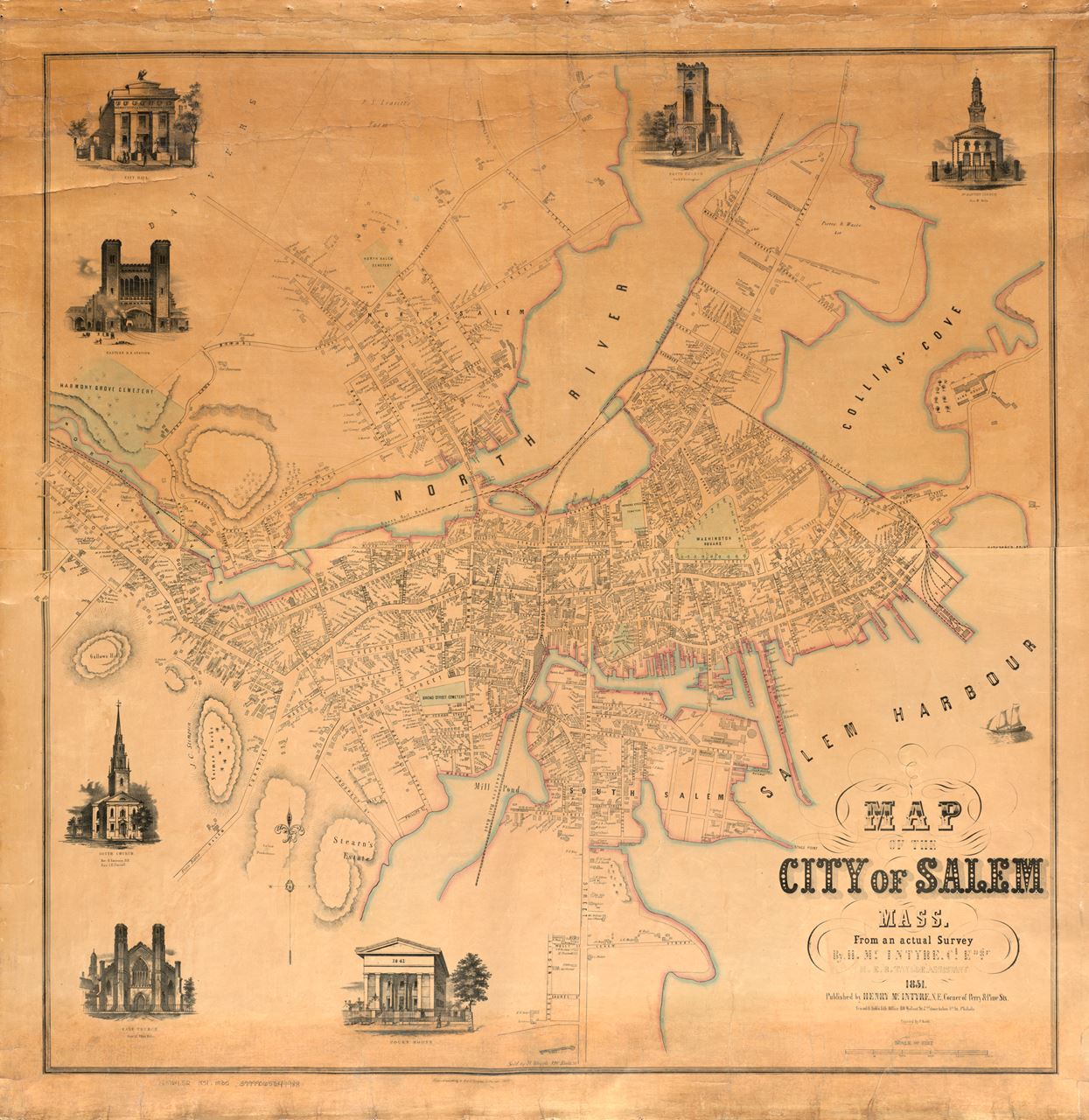
Map #5: McIntyre, H. (Henry), and Taylor, H. E. B.. "Map of the city of Salem, Mass." Map. 1851. Norman B. Leventhal Map & Education Center. https://collections.leventhalmap.org/search/commonwealth:9g54xk154.
Did you know that Kosciusko Street did not exist prior to 1820? Records show that Benjamin Hawkes laid out a street or "way" to access his shipbuilding yard between Daniels Street and Derby Wharf. The unnamed street appears on the map from 1851. In 1874 the street was named Grant Street in honor of Ulysses S. Grant. Its current name, Kosciusko Street, was given to the street in the 20th century when the area became home to Polish immigrants. The street is named after the Lithuanian-Polish Revolutionary War Brevet Brigadier General, Tadeusz Kościuszko.
The House Controversy
In the Massachusetts Historical Commission report, the current structure is described as "astylistic” with some Federal and Greek Revival detail." According to the report there is some disagreement to when the building was built and by whom. However, historians agree that the current building has undergone extensive additions and alterations.
According to the report done by Charles Snell for the Salem Maritime National Historic Site, the 17th century dwelling no longer stands. He believes that the structure was built in 1821 by Benjamin Hawkes. According to The Essex Antiquarian, volume 10 (1906), the structure associated with the 17th century owners, especially that of Nicholas Chattwell and Thomas Downing, was still standing by 1800 when Thomas Palfrey took over the property. This aligns with the research done by Edward Windsor Carberg. Joyce King dates the house to a structure built by Thomas May on the property he leased from the Palfrey Family. She believes that the structure still stood when Benjamin Hawkes took over the property.
The structure is truly a mystery. Some features like the two large chimneys and corresponding fireplaces, irregularly hewn beams in middle rooms and parts of the basement, and the remnants of what appears to be a kitchen hall in the basement, suggests that part of the house could possibly date from the early 18th century. The slender front chimney, elegant front fireplace, and beautiful floorboards suggest a dwelling from the late 18th century or early 19th century.
Like most structures in the area, this building was probably used as a home and place of business. One thing is for certain, the building and the people who lived here represents a microcosm of Salem’s history and community.
|
|


Map #6: Hopkins, Griffith Morgan. Atlas of the city of Salem, Plate A, "Wards 1 and 2." Massachusetts. Philadelphia, PA: G.M. Hopkins & Co., 1874. https://id.lib.harvard.edu/curiosity/scanned-maps/44-990057342200203941.
While the Irish have been part of Salem’s history from the very beginning, the growth of the railroads and the establishment of industry in the first half of the nineteenth-century saw an uptick in Irish immigration. However, the famine of 1845 caused a tremendous influx of Irish immigration to America. Those who came to Salem worked in the leather tanneries and shoe factories, and lived in the Derby Street neighborhood.
This structure at 159 Derby Street (101 Derby Street) was inhabited by Irish immigrants from 1860 to 1920. The property was owned by James Cochran who leased the dwelling to a family of Irish immigrants in 1860, Mary and James Concoran and their eight children. James was a peddler and all of his sons are listed in the records as "mariners." Three other Irish immigrants lived on the property, Bridget and and Thomas Condry, shoemaker, and their infant daughter, Mary.
James Cochran sold the property, which included two houses (159 Derby Street and 6 Kosciusko Street), to William Walsh in 1870. Within two years, the property was sold and transferred between the members of the Walsh family until Michael Walsh became sole owner. The Walsh family owned the property until 1920 and boarded Irish immigrants. In 1919, the property was transferred to Catherine Walsh and James Doyle. They would be the last Walshes to own the property.
1920 - 1940
|
|
In 1921, Catherine Walsh and James Doyle sold the houses and property to Victoria and Harry Lesiuk, Ukrainian immigrants. The sale of the property and its transfer to the trustees of the John Franco Society, Assembly 703 of the Ukrainian’s Workingmen’s Association, is indicative of the change in the residents of Derby Street. By the late nineteenth-century, Polish and Ukrainian immigrants settled the area. Driven out of their homeland by various wars, famines, and political shifts, the Poles and Ukrainians came to Salem to work in the shoe and leather factories, and in other industries. Derby Street and the surrounding area was the home of Salem’s growing Slavic population. St. Joseph’s Hall at 160 Derby Street and the Ukrainian’s Workingmen’s Association at 159 Derby Street provided newly arrived immigrants with community, housing, and job placement. These organizations provided the structural network that newly arrived immigrants needed in order to survive.
In 1927, the ownership of the property transferred directly to the John Franco Ukrainian Society. On May 15, 1934, the society sold the property to one of its members, Samuel Jaroma, a leather worker.
| The Salem Arts Association stands in solidarity with Ukraine and all Ukrainians here and abroad. Our organization’s building, as noted above, has a direct connection to the Ukrainian population here in Salem. Click here for a list of approved organizations to support Ukraine |

1940 - Present
The property changed hands a number of times over the last 80 years.
1949 - Samuel Jaroma sold the houses to George and Rose Andros on February 14, 1949. 1951 – George and Rose Andros sold the property and houses to Vincent R. McNeil, Jr. and Shirley E. McNeil on May 14, 1951.
1973 – Vincent and Shirley McNeill sold the property to Ernest and Virginia Santin on June 18, 1973
The Santin family operated a variety of businesses at 159 Derby including and ice cream Shop, Gift Shop, and an antique store. Santin family members also lived in two apartments on the second floor during this time.


1985 – Ernest and Ann Santin sold the property to Joseph Polizzotti on December 30, 1985
1987 – Joseph Polizzotti sold the property to Paul Nathan, the current owner, on May 1, 1987
Until 2019, the Nathan & Krevat Law Firm inhabited the building. Paul Nathan, An artist in addition to being an attorney, Dedicated his time to his artistic endeavors in his retirement. Nathan ran the Paul Nathan Gallery and Museum from the building until meetng Salem Arts Association and entering into an agreement to share the space and work towards a vision to establish a destination fo the arts at 159 Derby Street.
Salem Arts Association moved to the building in 2020.

References
"159 Derby Street, SAL.2643." Massachusetts Cultural Resource Information System. Accessed August 2. 2021. http://mhc-macris.net/Details.aspx?Mhcld=Sal.2643
Flibbert, Jospeh. Salem: Cornerstone of a Historic City. Beverly, MA: Commonwealth Editions, 1999.
Historic Salem, Inc. “ 159 Derby Street, Salem, Massachusetts 01970.” House Histories of Salem. Accessed August 2, 2021. https://hsihousehistory.omeka.net/items/show/274.
Perley, Sidney. "Salem in 1700, no. 24." The Essex Antiquarian: An Illustrated Magazine Devoted to the Biography, Genealogy, History and Antiquities of Essex County Massachusetts 10 (Jan 1906): 114; 125-126. https://hdl.handle.net/2027/mdp.39015030567187.
Massachusetts Cultural Information Resource System (MCIRS), Document SAL.2643. https://mhc-macris.net/Details.aspx?MhcId=SAL.2643
Snell, Charles W.. "Historic Sites Survey Report: (Some Derby Street Houses and Inhabitants) — Data on the Physical History of House Lots 3, 4, 5, 6, 7, 8, 10, and 11; Waterfront Lot J, and the East Side of Union Wharf, 1660-1869, Salem Maritime National Historic Site, Massachusetts." Denver Service Center, Historic Preservation Division, National Park Service, United States Department of the Interior, November 1979. http://www.npshistory.com/publications/sama/hssr-derby-st-houses.pdf
Maps
Map #1: Upham, William P. (William Phineas). “Map of Salem Village in 1692,.” Map. 1866. Salem Public Library. https://digitalheritage.noblenet.org/salem/items/show/107.
Map #2: Freeman, William W. K. “Part of Salem in 1700, based on the Research of Sidney Perley." Map. 1933. Salem Public Library. https://digitalheritage.noblenet.org/salem/items/show/36.
Map #2a: Perley, Sidney. "Salem in 1700, no. 24." Illustration in The Essex Antiquarian: An Illustrated Magazine Devoted to the Biography, Genealogy, History and Antiquities of Essex County Massachusetts 10 (Jan 1906): 114.
Map #3: Saunders, Jonathan Peele, and Annin & Smith. "Plan of the Town of Salem in the Commonwealth of Massachusetts." Map. 1820. Norman B. Leventhal Map & Education Center. https://collections.leventhalmap.org/search/commonwealth:3f4631459.
Map #4: Snell, Charles W.. "Property Map of the Salem Waterfront Lots and House Lots, 1750-1799." Illustration in "Historic Sites Survey Report: (Some Derby Street Houses and Inhabitants) — Data on the Physical History of House Lots 3, 4, 5, 6, 7, 8, 10, and 11; Waterfront Lot J, and the East Side of Union Wharf, 1660-1869, Salem Maritime National Historic Site, Massachusetts." Denver Service Center, Historic Preservation Division, National Park Service, United States Department of the Interior, November 1979, p. 201. http://www.npshistory.com/publications/sama/hssr-derby-st-houses.pdf.
Map #5: McIntyre, H. (Henry), and Taylor, H. E. B.. "Map of the city of Salem, Mass." Map. 1851. Norman B. Leventhal Map & Education Center. https://collections.leventhalmap.org/search/commonwealth:9g54xk154.
Map #6: Hopkins, Griffith Morgan. Atlas of the city of Salem, Plate A, "Wards 1 and 2." Massachusetts. Philadelphia, PA: G.M. Hopkins & Co., 1874. https://id.lib.harvard.edu/curiosity/scanned-maps/44-990057342200203941.
Images
Deed transferring the property from Richard Downing to Warwick Palfrey, November 17, 1721. (from the collection of Salem Arts Association)
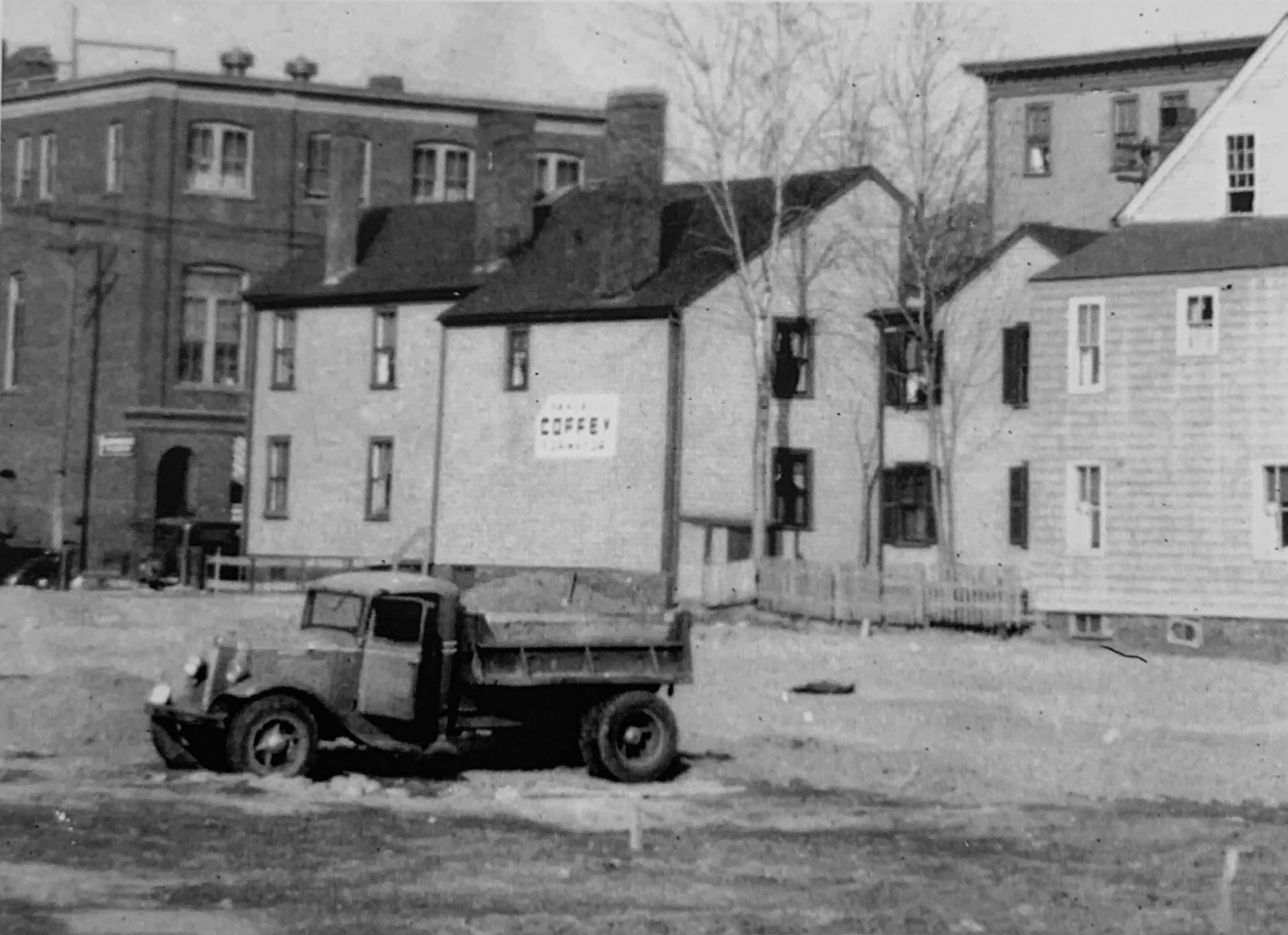
Photo: image of 159 Derby Street viewed form field (not the Historic Salem Maritime National Historic Site). Estimated for 1930's
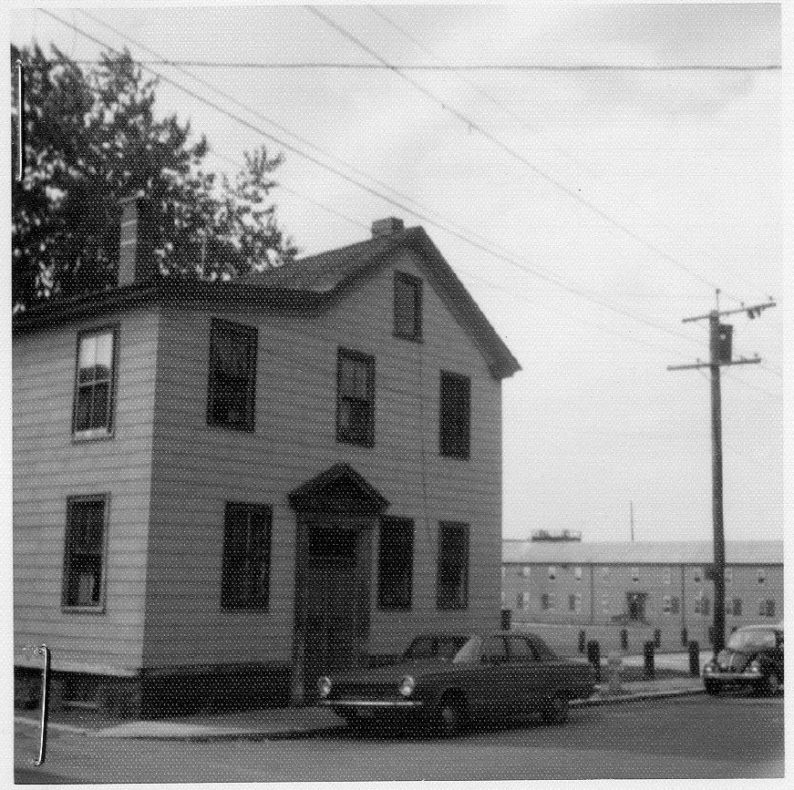
Photo: View of 159 Derby Street 1972 - Massachusetts Cultural Information Resource System (MCIRS), Document SAL.2643, Page 8. https://mhc-macris.net/Details.aspx?MhcId=SAL.2643
Salem Arts Association | Hours Parking: on street when available |
![]()
![]()
![]()
![]()
© 2007 - 2025, Salem Arts Association is a 501(c)(3 )non-profit organization
159 Derby Street, Salem MA 01970